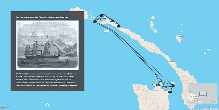
Map-based storytelling of historical sea voyages with a vague spatiotemporal data basis

| Led by: | Fuest, Sester |
| Year: | 2024 |
Introduction and goal of the thesis
The thesis topic is related to the DiViAS project (digitization, visualization and analysis of collection items) which brings together scientific methods and practices for digitizing, researching and representing collections from colonial contexts. The project involves developing new approaches for making sense of the information derived from historical sources such as logbooks or travel reports. One of the project goals is to make the movements of ships, people and objects traceable, which can be facilitated by cartographic representations of these movements. In fact, many of these processes can only be understood in a temporal context. Since the information provided in the historical sources is oftentimes vague, inaccurate or incomplete, a visual representation using narrative techniques such as storymapping may facilitate understanding the spatiotemporal sequence of the events that happened throughout the journey.
The aim of the thesis is therefore to adequately communicate spatiotemporal phenomena and relationships between the journeys of ships, objects and persons, as well as the activities that happened at different locations along the route – in a comprehensive and visually appealing way. One focus of this thesis should be to develop modalities to visualize the uncertainty and vagueness, e.g. vagueness about a route, about a potential place visited but not exactly documented, or about the effect of certain events, such as storms. Besides static information, also animations and dynamics shall be investigated to convey certain information (e.g. landings, ship captures). Templates for certain states, events and actions shall be developed, which later can be flexibly used to generate route descriptions.
As part of the thesis, a web map will be set up that allows presenting the data in a narrative format (using specific templates). Within this web environment, a storymap is exemplarily created for an example route; the transferability to other routes using the templates shall be shown. Finally, the usability of the storymap needs to be tested and evaluated.
Tasks and schedule
- Literature research on storymapping and familiarizing with the data
- Identifying and developing templates for states, events and actions
- Setting up a web map that allows presenting the data in a narrative format
- Create a storymap for an example route within the web environment
- Usability test of the created storymap
- Writing the documentation (thesis)
Resources
Sample datasets from the DiViAS project: The available data contains descriptions of waypoints of various ship routes of the 17th and 18th centuries resulting from transcribed logbooks with information such as location, time or event, which in turn are subject to vagueness.
Requirements
- Programming skills
- Ability to access and query data from a database
- Experience in working with Geographic Information Systems (GIS)
- Experience in web development
- Ability to work independently
- Interest in creative work
References
Schnürer, R. (2023). Storytelling with Animated Interactive Objects in Real-time 3D Maps (Doctoral dissertation, ETH Zurich).
Roth, R. E. (2021). Cartographic design as visual storytelling: synthesis and review of map-based narratives, genres, and tropes. The Cartographic Journal, 58(1), 83-114.
DiViAS project homepage (2024). https://divias.de/en/
Contact persons
Dr.-Ing. Stefan Fuest (E-Mail stefan.fuest@ikg.uni-hannover.de, Tel. 762-5285)
Prof. Dr.-Ing. habil. Monika Sester (E-Mail monika.sester@ikg.uni-hannover.de)
